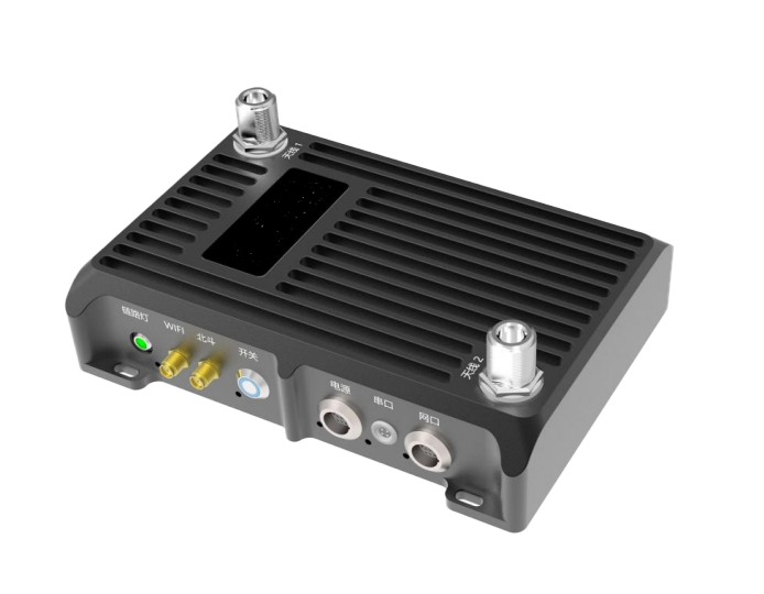

The BDXY-710 all-in-one runway calibration system integrates key functional modules such as satellite navigation antenna unit, satellite navigation receiver, receiving equipment, receiving antenna, wireless WiFi module, WiFi antenna, battery module, and control unit. The satellite navigation antenna is used to receive the satellite signal, the satellite signal is tracked by the satellite navigation and positioning board and the differential information sent by the receiving equipment is RTK to calculate the high-precision position information of the measurement coordinate point, and the calibration point coordinate information is transmitted to the user display control interface through WiFi. The system is compact and portable, making it an excellent solution for outdoor applications.
Indicator parameters:
| passage
| 555 passage |
| Constellation
| BDS/GPS/GLONASS |
| Frequency | BDS:B1/B21 GPS: L1/L2 GLONASS: L1/L2 |
| Positioning accuracy
| Single Point Positioning (RMS) Plane : 1.5m Elevation: 2.5m DGPS (RMS) Plane : 0.4m Elevation: 0.8m RTK (RMS) Plane : 1cm 1ppm Elevation: 1.5cm 1ppm |
| Time Accuracy (RMS)
| 20 ns |
| Velocity accuracy
| 0.03 m/s |
| Time to first fix
| Cold start<50s |
| Hot start <30s | |
| Lock recovery time | <2s |
| Initialization reliability
| >99.9% |
| WIFI frequency range
| 2.412GHz-2.484GHz |
| Radio frequency range
| 450MHz-470MHz |
| Data update rate
| 5Hz positioning
|
| Differential data
| RTCM3.X |
| data format
| NMEA-0183 |
| Physical
| |
| Dimensions
| 187mmX187mmX102mm |
| Weight
| 1.6kg |
| Battery capacity
| 7000mAh |
| Environmental
| |
| Temperature
| 95% non-condensing
|
| Vibration
| GJB150.16A-2009,MIL-STD-810 |
| Shock
| GJB150.18A-2009,MIL-STD-810 |
| Operating Temperature | -40℃~+85℃ |
Storage Temperature | -55℃~+90℃ |
| Connector
| |
| Data interface | 12Pin Lemo |
| Communication interface
| 1xRS232 1xRS422 |


Long Press to Scan QR Code
Scan QR Code